

 3:47:32
  2023-09-11
  1597
1597

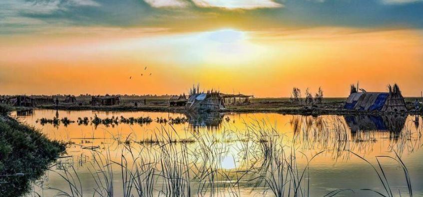
The Iraqi Marshes are located in the lower Mesopotamian basin, in the vast floodplain wetlands created by the Tigris-Euphrates river system. The marshlands used to be the largest wetland ecosystem in Western Eurasia, representing a rare aquatic landscape in the desert and providing a habitat for important populations of wildlife. The marshlands form a triangular region bounded by three of the largest cities in southern Iraq: Nasiriyah to the west, Amarah to the north-east and Basra to the south. The inhabitants of the marshlands are known as Marsh Arabs.
Downstream of the capital Baghdad, approximately 500 kilometres from the head of the Persian Gulf, the very weak longitudinal slope of the land causes the two great rivers to meander and split into multiple branches, creating a chain of almost interconnected shallow freshwater lakes, marshes and seasonally inundated floodplains that typically overflow and merge into larger complexes during periods of high floods.
The average depth of water in the marshland is between 0.5 metres in the dry season and 2 metres in the wet season, and may be several metres deep in the permanent lakes. The Iraqi Marshes encompass three distinct areas: Hawizeh Marsh; Central Marsh, which formally includes Abu Zirig Marsh; and Hammar Marsh (Map 1). Current settlements and activities within and adjacent to the marshes include villages and towns, agricultural areas and oilfields.
Climate
With less than 200 millimetres of annual rainfall, the climate in the marshlands is arid subtropical. It is characterized by hot summers (with average maximum temperatures around 43°C) and mild to cool winters (with average minimum temperatures around 4°C). In the summer, dust storms are common and heat waves can raise the temperature to 48°C. During the winter, the temperature can drop to -8°C. Humidity is low and evaporation from free water surfaces is high, causing water losses due to evaporation ten times higher than rainfall contribution over the area.
Hydrology
Before the 1970s, there was a complex system of natural channels where the Tigris and Euphrates formed interior deltas upstream of the marshes, and the marshes created a highly interconnected system in which the rivers merged and disappeared. This natural system has been altered in the last century with the implementation of agricultural canals, drainage systems and hydraulic structures, which impact significantly the hydrological management of the entire system.
Water from the Tigris feeds the Hawizeh and Central marshes due to the inadequate carrying capacity of its channel. The main Tigris channel reduces its cross-sectional area as it nears the marshes; the river flow capacity decreases significantly.
The Euphrates is constrained by higher embankments all the way from Nasiriyah to Qurnah. Nevertheless, secondary branches exist and are able to connect the Central Marsh to the Euphrates via a number of breaches along the north embankment of the Euphrates. The Euphrates is divided into several arms downstream of Nasiriyah and flows into the Hammar Marsh along several secondary channels; the main branch of the Euphrates flows toward the confluence with the Tigris at Qurnah, but is currently blocked by a dyke that facilitates overflow through the wetlands.
Water from the Hammar Marsh flows into the Shatt al-Arab and Shatt al-Basra rivers through Qarmat Ali, whereas the Central Marsh flows into the upper reach of the Euphrates and then, at Qurnah, into the Shatt al-Arab. Water from the Hawizeh Marsh flows back into the Tigris and the Shatt al-Arab.
Formation of the marshes
The marshlands originated in the Holocene era. Some researchers claim that in about 5,000-4,000 BC, the marshlands were covered by a lagoonal marine environment, likely having brackish waters. With rising sea levels after a glacial period, the rivers began to deposit sediment and create vast deltas, which caused the shoreline to progress to its present location, possibly between 3,000-1,000 BC. The present fresh-to-brackish water environment is estimated to have been established around 3,000 years ago.
Early history of the marshlands
Some of the earliest records of civilization are on the fringes of the marshlands. Little archaeological exploration has been carried out within the marshes themselves. Mounds, known as tells, rising above the marsh waters are believed to be the sites of ancient cities.
The Sumerians flourished around the marshlands between 3,000 and 2,000 BC. The Epic of Gilgamesh, the world’s first epic poem, mentions the marshlands: ‘Ever the river has risen and brought us the flood’. Artefacts in the Iraqi Museum represent Gilgamesh with water buffaloes in the Tigris and Euphrates. The boats used by marsh dwellers today are almost identical to those found at the Royal Cemetery of Ur. Clay tablets from the Sumerian period describe the marshes’ abundant wildlife.
The Sumerians were followed by the Assyrians. The Assyrians called the marshes Narmrtu (‘the bitter water’) or Tamdu Shamatu Kildi (‘the sea of the city of Kildah’).
Reality Of Islam |
|

Labor short

A new ultra

Batteries p
 9:3:43
 2018-11-05
10 benefits of Marriage in Islam
 7:5:22
 2019-04-08
benefits of reciting surat yunus, hud &
 9:45:7
 2018-12-24
advantages & disadvantages of divorce
 11:35:12
 2018-06-10
 6:0:51
 2018-10-16
 6:0:8
6:0:8
 2023-03-19
 8:25:12
 2022-03-09
 6:14:3
 2023-01-18
 2:42:26
 2023-02-02
 4:25:57
 2023-02-11
 10:35:40
 2022-05-26
 7:34:7
 2023-02-28
 5:41:46
 2023-03-18
| LATEST |