


النبات

مواضيع عامة في علم النبات
الجذور - السيقان - الأوراق
النباتات الوعائية واللاوعائية
البذور (مغطاة البذور - عاريات البذور)
الطحالب
النباتات الطبية
الحيوان
مواضيع عامة في علم الحيوان
علم التشريح
التنوع الإحيائي
البايلوجيا الخلوية
الأحياء المجهرية
البكتيريا
الفطريات
الطفيليات
الفايروسات
علم الأمراض
الاورام
الامراض الوراثية
الامراض المناعية
الامراض المدارية
اضطرابات الدورة الدموية
مواضيع عامة في علم الامراض
الحشرات
التقانة الإحيائية
مواضيع عامة في التقانة الإحيائية
التقنية الحيوية المكروبية
التقنية الحيوية والميكروبات
الفعاليات الحيوية
وراثة الاحياء المجهرية
تصنيف الاحياء المجهرية
الاحياء المجهرية في الطبيعة
أيض الاجهاد
التقنية الحيوية والبيئة
التقنية الحيوية والطب
التقنية الحيوية والزراعة
التقنية الحيوية والصناعة
التقنية الحيوية والطاقة
البحار والطحالب الصغيرة
عزل البروتين
هندسة الجينات
التقنية الحياتية النانوية
مفاهيم التقنية الحيوية النانوية
التراكيب النانوية والمجاهر المستخدمة في رؤيتها
تصنيع وتخليق المواد النانوية
تطبيقات التقنية النانوية والحيوية النانوية
الرقائق والمتحسسات الحيوية
المصفوفات المجهرية وحاسوب الدنا
اللقاحات
البيئة والتلوث
علم الأجنة
اعضاء التكاثر وتشكل الاعراس
الاخصاب
التشطر
العصيبة وتشكل الجسيدات
تشكل اللواحق الجنينية
تكون المعيدة وظهور الطبقات الجنينية
مقدمة لعلم الاجنة
الأحياء الجزيئي
مواضيع عامة في الاحياء الجزيئي
علم وظائف الأعضاء
الغدد
مواضيع عامة في الغدد
الغدد الصم و هرموناتها
الجسم تحت السريري
الغدة النخامية
الغدة الكظرية
الغدة التناسلية
الغدة الدرقية والجار الدرقية
الغدة البنكرياسية
الغدة الصنوبرية
مواضيع عامة في علم وظائف الاعضاء
الخلية الحيوانية
الجهاز العصبي
أعضاء الحس
الجهاز العضلي
السوائل الجسمية
الجهاز الدوري والليمف
الجهاز التنفسي
الجهاز الهضمي
الجهاز البولي
المضادات الميكروبية
مواضيع عامة في المضادات الميكروبية
مضادات البكتيريا
مضادات الفطريات
مضادات الطفيليات
مضادات الفايروسات
علم الخلية
الوراثة
الأحياء العامة
المناعة
التحليلات المرضية
الكيمياء الحيوية
مواضيع متنوعة أخرى
الانزيمات

World Climate
 المؤلف:
AN INTRODUCTION TO PLANT BIOLOGY-1998
المؤلف:
AN INTRODUCTION TO PLANT BIOLOGY-1998
 المصدر:
JAMES D. MAUSETH
المصدر:
JAMES D. MAUSETH
 الجزء والصفحة:
 16-10-2016
 3058
3058


+
-
20
World Climate
Earth's climatic conditions are the result of its tilted axis of rotation and the presence of the atmosphere and oceans.
EFFECTS OF EARTH'S TILT
Imagine a planet whose axis of rotation is exactly perpendicular to the plane of its orbit. At the equator, the sun would rise exactly in the east every day of the year; it would pass directly overhead and set in the west. There would be no change, no seasons. At all sites not on the equator, 70 degrees N for instance, the sun would never be overhead; every day it would rise in the southeast, pass low in the sky, and set in the southwest. Maximum heating would be at the equator; all other regions would always receive only oblique lighting and would be much cooler. If there were no atmosphere or oceans, heat could not be transferred from the equator to the poles, and there would be a tremendous temperature gradient between those regions.
Earth's axis of rotation is tilted 23.5 degrees away from perpendicular to the orbital plane. At summer solstice, June 21 or 22, the North Pole points as directly toward the sun as possible, and in the Northern Hemisphere, the sun has reached its highest point in the sky. The sun appears to be overhead at noon for those people located at 23.5 degrees N latitude, the Tropic of Cancer, which runs just south of California, Texas, and Florida. The days are their longest and summer has officially begun. North of the Arctic Circle, the sun is visible even at midnight.
As Earth continues its orbit, the axis of rotation points less toward the sun, which appears to rise and set more to the south and is lower in the southern sky at noon. By September 23, autumnal equinox, Earth has made one-quarter orbit, the sun is directly over the equator, and days are exactly 12 hours long: Autumn begins. After another 3 months, winter solstice, December 21 or 22, the South Pole points as directly as possible toward the sun; the sun is directly over the Tropic of Capricorn, 23.5 degrees S latitude. Summer begins in the Southern Hemisphere, but in the north, winter begins and the days are at their shortest; above the Arctic Circle, the Sun never rises. With another one-quarter orbit, the sun moves back toward the equator, arriving there at March 21, the vernal equinox.
The most intense solar heating is not confined simply to the equator, but rather moves seasonally northward, then southward. All parts of the planet experience seasonality, although in the region between 23.5 degrees N and 23.5 degrees S, the tropics, not as much change occurs between summer and winter as in the temperate regions outside this band.
ATMOSPHERIC DISTRIBUTION OF HEAT
The atmosphere and oceans, being fluids, develop convection currents and massive flows when heated in one area and cooled in another. They distribute heat from the tropics to the temperate regions and all the way to the poles.
Much of the tropical zone is occupied by the Pacific, Atlantic, and Indian Oceans (Fig. 1). Throughout the year, the water and air receive solar heat, causing tremendous amounts of evaporation into the air. The air warms, expands, then rises high into the atmosphere. As it flows upward, the surrounding air pressure decreases, and the moist rising air expands even more. The expansion causes the air to cool, decreasing its ability to hold moisture. Water vapor condenses into rain and falls back to the surface in torrential storms, producing tropical rainforests in Central America, northern South America, central Africa, and Southeast Asia.
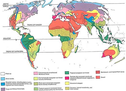
FIGURE 1: Most land on Earth is distributed rather far north at present, and the tropical zone, between the Tropics of Cancer and Capricorn, is mostly water. The greatest amount of solar energy falls on water, causing great evaporation and humidifying the atmosphere but leading to relatively little temperature change. If more land were in the tropics, the soil would heat more, which in turn would heat the air, but the oceans would stay cool and evaporate little moisture to the atmosphere; all regions would receive much less rain
After rising, the air is pushed northward and southward by the continued rising of more tropical air below it (Fig. 2). While spreading at high altitude, the air radiates heat to space, cooling even more. By the time it reaches about 30 degrees N or S latitude (the horse latitudes) it has cooled, contracted, and become dense enough to sink. It encounters greater atmospheric pressure at lower altitudes and is compressed and heated. As it warms, its water-holding capacity increases. Because its capacity to hold water is greater but its water content is the same, the air has become drier. But it had already lost much of its moisture while initially rising, so it is now extremely dry. Land areas below this descending air contain the world's hot, dry desert biomes (Fig. 1).
Once back at Earth's surface, part of the air spreads toward the equator and part flows toward the poles. Earth's rotation causes the air moving toward the equator to be deflected westward. It moves as a northeast trade wind in the Northern Hemisphere and a southeast trade wind in the Southern Hemisphere. Air spreading toward the poles from the horse latitudes is deflected eastward and blows as a prevailing westerly.
The actual area of descending dry air varies with the season, being farther north when the sun is near the Tropic of Cancer (Northern Hemisphere summer) and farther south when the sun is near the Tropic of Capricorn. The United States, during its winter, is located entirely within the influence of the prevailing westerlies; all winter weather comes from the Pacific and Arctic Oceans, moving eastward across the continent. During summer in the United States, the northeast trade winds have moved northward far enough to influence the states along the Gulf of Mexico; northeast tradewinds bring summer storms westward from the Atlantic onto the east coast and gulf, supplying summer rains.

FIGURE 2: Air rises above the equator and then spreads northward and southward at high altitudes. By the time it has reached the tropics, it is cool enough to contract, become dense, and sink. At the surface, some flows back toward the equator as tradewinds, and some continue toward the poles as prevailing westerlies. The entire pattern is shifted northward during the Northern Hemisphere summer and southward during the winter.
Continental Climate. The size of a land mass influences the weather it receives. Larger islands such as the Hawaiian Islands, Guam, and Puerto Rico have mountains that force air to rise as it blows across them. Rising air cools and rain forms. Low-lying, small islands like the Florida Keys and the smallest islands in the Bahamas are too flat to affect the air; these desert islands are extremely dry, often with no fresh water streams or lakes (Fig. 3).
Continents also cause air to rise, cool, and drop precipitation. If the topography is fairly flat, air rises gradually and rains are distributed over an extensive area. Summer storms from the Atlantic and Gulf of Mexico move through the eastern United States, the Mississippi Valley, and the plains states; the land rises so gradually that rainfall covers half a continent.
If topography is mountainous, as on the United States' west coast, rain is dropped in a narrow area. The prevailing westerlies bring moist air from the Pacific Ocean onto land.
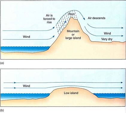
FIGURE 3: (a) When a mountain or other large land mass forces air to rise, the air expands because of the lower pressure at high altitude. If it cools below its dew point, it drops rain or snow. On the lee side of the mountain, descent of the air compresses and heats it, raising its ability to hold water. Rather than bringing rain to the area, it may actually dry out the soil. (b) A low island does not cause the air to rise, so that source of cooling is not present. Air blows across undisturbed, and the island receives little rain even though the air may be extremely humid.
Over California, Oregon, Washington, and western Canada. The air is immediately forced to rise by coastal mountain ranges—the Cascades in Oregon, Washington, and Canada and the Coastal Range in California. Strong rains fall on the western slopes, but after the air crosses the summit, it descends and warms and rains cease. The eastern slopes are much drier than the western ones. The decreased rain on the landward side of mountains is called a rain shadow. As air continues eastward, it encounters the Sierra Nevadas and the Rocky Mountains; these are higher than the coastal ranges, so air is forced upward again, far enough to cool it even more than before and more rain falls. Descending east of the Rockies, the air warms, rains cease, and the air moves across the central plains. By now the air is very dry and only rarely provides precipitation; if it were not for the Atlantic moisture moving northward out of the Gulf of Mexico, this area would be a desert instead of grassland (Fig. 4).
The size of a land mass also affects its temperature fluctuation. On a large island, moist air is always rising over the mountains, and clouds are frequent. Temperatures have a narrow range. Along the coasts of a continent, cloudy, rainy weather is frequent and temperature fluctuation is mild. Farther inland, air is dry and clear; lack of clouds exposes the land to full daytime insolation, and heating is rapid and extreme. At night, clear skies allow the land to radiate infrared energy into space, with none reflected by clouds; cooling is also rapid and extreme.
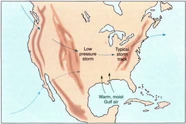
FIGURE 4: During our summer, tropical storms sweep west through the Caribbean, then turn to the north or northeast and bring moisture inland as far west as central Texas and north toward the Great Lakes. Fortunately, no southern coastal mountain range blocks this movement or the central and eastern United States would be very dry. During our winter, air circulation patterns move south so much that westerlies dominate the entire continent. Virtually all weather systems come from the west coast or Canada, dropping their moisture in the Rocky Mountains. Snow storms in the plains states drop little snow; along the northeastern United States some moist Atlantic air is drawn over land and mixes with cold western air, resulting in heavy snowstorms. The southeastern United States remains cool but not cold, receiving rain when moist Caribbean air occasionally pushes north over land. The southwestern United States tends to remain dry in winter, receiving some snowfall when Pacific westerlies push slightly northward
OCEANIC DISTRIBUTION OF HEAT
Water in the Pacific and Atlantic Oceans flows in giant circular currents driven by the air circulation patterns. The ocean currents distribute heat from the tropics to the poles, lessening the temperature gradient that would otherwise exist. Also, as warm tropical surface water moves to higher latitudes, large amounts of water evaporate into the temperate prevailing westerlies, giving them more humidity than they would have if the oceans did not circulate.
As the trade winds blow across the tropics from east to west, friction between air and water causes equatorial currents to form. During the weeks that a particular mass of water flows along the equator as part of the Atlantic Equatorial currents, it absorbs huge amounts of energy and warms significantly (Fig. 5). At the western side of the ocean basin, it is deflected northward by the tip of Brazil, then part is deflected by Florida and enters the Gulf of Mexico as a counterclockwise current. The water's warmth permits high evaporation into the air and keeps much of the gulf coast humid. The rest of the current moves along the east coast as the Gulf Stream; because this is latitude dominated by westerly winds, the warm current does not keep the land as warm and wet as one would expect. Near New Jersey and New York, the current turns eastward toward Europe; at the turning point, cold polar water moves south along the east coast of Canada and the northeastern United States.
The Pacific Ocean has a similar pattern with westerly equatorial currents. The Philippines and Indonesia act as a barricade, deflecting water north and south. The turn is abrupt and much northern water heads eastward as the Kuro Shio current toward Canada and Washington. Once at the west coast of North America, some water turns northward toward Alaska as the Alaska current, but the bulk turns south as the California current. The westerlies absorb huge amounts of moisture as they blow for thousands of miles across the warm Pacific waters, and even though much falls as rain over the ocean, a large amount remains in the air and keeps the coasts wet.
The constant friction of the trade winds not only powers the westerly equatorial currents but also actually causes water to pile up on the west side of an ocean. Directly at the equator the trade winds are relatively weak, and water is able to flow downhill from west to east as an equatorial countercurrent. This extremely warm water is deflected northward and moves along the west coast of Mexico and California, keeping them warm all year.
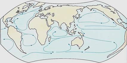
FIGURE 5: Ocean water in the two basins, Atlantic and Pacific, circulates in four giant circles, clockwise in the Northern Hemisphere and counterclockwise south of the equator. For the United States, this means that the warm waters that could moderate our climate and give us more precipitation are in the wrong place. The warm Gulf Stream supplies moisture to prevailing westerly winds that carry it across the narrow Atlantic to Europe. The warm current of the Pacific also supplies moisture to prevailing westerlies, but because the Pacific Ocean is so wide, much of the moisture is lost as rain as the air moves across the cooler water in the eastern Pacific.
 الاكثر قراءة في مواضيع عامة في علم النبات
 اخر الاخبار
اخبار العتبة العباسية المقدسة

الآخبار الصحية


مواضيع ذات صلة
 قسم الشؤون الفكرية يصدر كتاباً يوثق تاريخ السدانة في العتبة العباسية المقدسة
 "المهمة".. إصدار قصصي يوثّق القصص الفائزة في مسابقة فتوى الدفاع المقدسة للقصة القصيرة
 (نوافذ).. إصدار أدبي يوثق القصص الفائزة في مسابقة الإمام العسكري (عليه السلام)